In MERMAID, each transect or quadrat collection you complete in the field—whether it's a fish belt, benthic PIT, or a bleaching rapid assessment—is recorded in the platform as a sample unit. A sample unit represents one instance of data collection using a specific survey method at a specific site on a specific date. It’s the building block of your project dataset in MERMAID.
Filling out a sample unit form
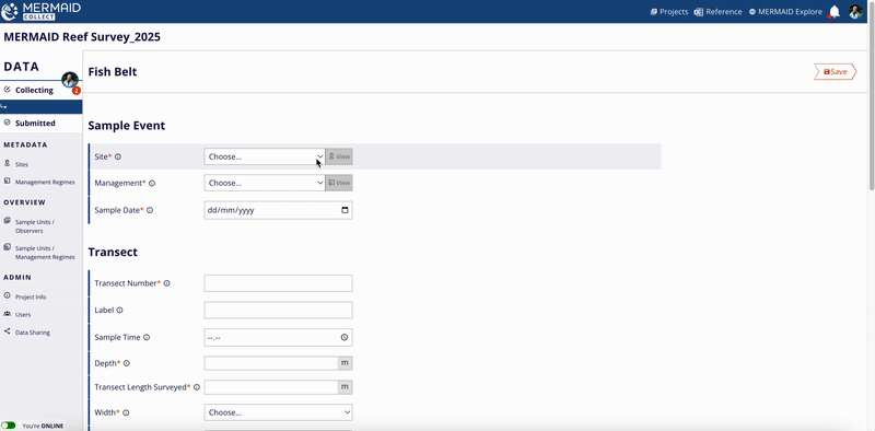
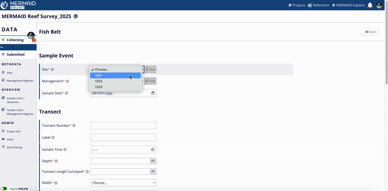
When you’re ready to enter data from your dive sheets, go to your project’s Collecting page and click + Add sample unit. You’ll then select the appropriate method and fill out a structured form organized into four consistent sections (Sample event, Transect/Quadrat collection, Observers, Observations).
Note: Required fields are marked with a red asterisk (*). These include site, management regime, observers, and key transect attributes. Optional fields include time, visibility, current, tide, and notes. Helper text is available for every field—just click the info icon next to a label to view tips, definitions, and example entries. |

1. Sample event
This section defines where and when the data was collected. You'll select:
Site – From the list of sites added to the project. Learn more about adding sites here.
Management regime – From the list of management regimes added to the project. Learn more about adding regimes here.
Date of survey – The date the sample unit was collected.
Each sample event (site, management regime, and date) is used to group your sample units for the reef health metrics calculations in MERMAID. Read more in Learning about Our Reef Health Metrics.

2. Transect/Quadrat collection
This section captures the protocol-specific details of the survey method used. Every method has tailored fields, such as:
Survey method | Protocol-specific fields |
Fish belt | Transect length surveyed (m) Belt width (m) Fish size bin (cm) |
Benthic PIT | Transect length surveyed (m) Interval size (m) Interval start (m) |
Benthic LIT | Transect length surveyed (m) |
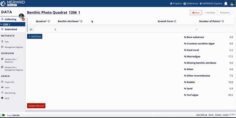
Benthic photo quadrat | Quadrat number start Quadrat size (m2) Number of quadrats Number of points per quadrat |
Bleaching | Quadrat size (m2) |
Habitat complexity | Transect length surveyed (m) Interval size (m) |
Macroinvertebrate belt | Transect length surveyed (m) Belt width (m) Macroinvertebrate size bin (cm) |
You’ll also enter general information like:
Transect number
Depth (m)
Optional context – Label, sample time, reef slope, visibility, current, relative depth, tide, notes
Some fields use dropdowns with standardized values (e.g., belt width, fish size bins); others are free text or numeric fields for flexibility (e.g., transect length surveyed, interval size).
3. Observers
In this section, assign the person(s) who collected the observations underwater:
Select from the list of project users
Click to add or remove names
At least one observer is required per sample unit
Accurate attribution helps with training, reporting, and quality assurance.
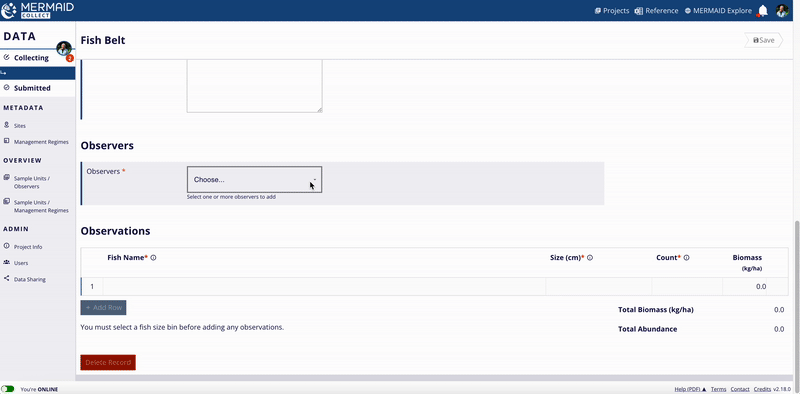
4. Observations
Here’s where you enter your actual data (raw observations):
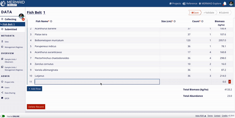
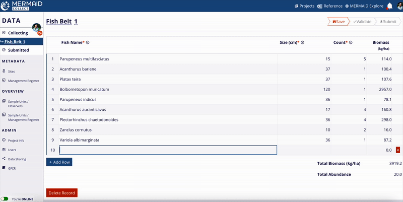
For Fish belt: fish name, size (cm), and count
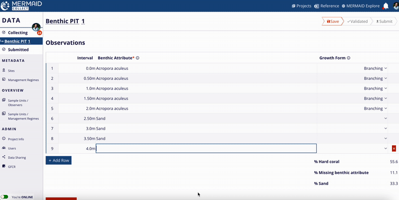
For Benthic PIT: attribute name and growth form (if applicable) per interval (m)
For Benthic LIT: attribute name, growth form (if applicable), and length (cm)
For Benthic photo quadrat: quadrat number, attribute name, growth form (if applicable), and number of points
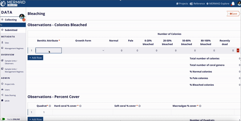
For Bleaching: coral genus, bleaching severity
For Habitat complexity: habitat complexity score per interval (m)
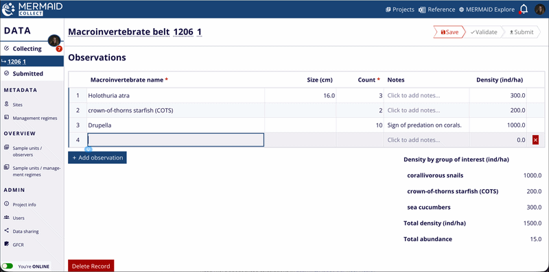
For Macroinvertebrate belt: macroinvertebrate name, size (cm), and count
Suggesting a new benthic attribute, fish species , or macroinvertebrate species
While entering your observations, if there is a benthic attribute, fish, or macroinvertebrate species that isn’t yet listed in the dropdown, you can propose a new one directly while entering observations in the Observations table.
To propose a new benthic attribute:
Type the new benthic attribute in the Observations table, and select Propose new benthic attribute… from the dropdown.
Enter the coral genus/family/top-level category in Parent and the species/genus in Name.
Click Next to review your suggestion.
Click Send to MERMAID to submit it for review.
To propose a new fish or macroinvertebrate species:
Type the new fish or macroinvertebrate species in the Observations table, and select Propose new species… from the dropdown.
Select a Genus name from the dropdown and enter the Species name.
Click Next to review your suggestion.
Click Send to MERMAID to submit it for review.
If the genus you’re trying to add isn’t found in MERMAID’s taxonomic reference, select Contact us for help from the dropdown to notify the MERMAID Team.
Before suggesting a new benthic attribute, fish or macroinvertebrate species to MERMAID, please verify that the species is officially recognized in the World Register of Marine Species (WoRMS). This helps ensure consistency and accuracy in our database.
Once you’ve sent your suggestion for review, it is immediately added to your sample unit as a provisional observation. However, it becomes an official part of MERMAID’s taxonomic reference only after it has been reviewed and approved by the MERMAID Team. Once approved, it will be available to all users and included in the metrics calculation.
You can view the full list of available benthic attributes, fish and macroinvertebrate species by clicking the Reference icon at the top of any page in MERMAID Collect. This will download an up-to-date MERMAID taxonomic reference file.
Viewing metric summaries in a sample unit
As you enter observations in a sample unit, MERMAID automatically calculates and displays key metric summaries to provide quick insights and support data quality checks — all available even when you’re offline.
Read more in Learning About Our Taxonomic Reference.
Explore the metric summaries available for each survey type below:
Fish Belt
For fish belts, total biomass (kg per hectare), using length-weight coefficients from FishBase (Bayesian estimates), and abundance (total count of individuals) are calculated in real-time . These are applied automatically to your fish name, size, and count entries based on the survey area (i.e., transect length and width). MERMAID uses standardized fish taxonomy from the World Register of Marine Species (WoRMS) to ensure consistency.
Note: If you are not seeing biomass estimates beneath the Observations table, make sure both the transect length and belt width are entered in the Transect Details section—these are required to calculate biomass per area. |
Benthic PIT, LIT, and Photo Quadrat
For all benthic methods, percent cover is automatically calculated for each top-level benthic category (e.g., hard coral, soft coral, macroalgae) based on the observations you enter. These percentages are displayed beneath the Observations table. Each benthic attribute entered is hierarchically grouped into these broader categories commonly used in global reef monitoring.
Bleaching
For bleaching surveys, MERMAID calculates:
Total number of coral colonies
Total number of coral genera
Percent colonies by bleaching severity level (normal, pale, and bleached)
Percent cover of hard coral, soft coral, and macroalgae
These metrics appear below the Observations table and help you evaluate the extent of bleaching in real time.
Habitat Complexity
For habitat complexity surveys, MERMAID calculates the average complexity score (scale 0–5) across all intervals entered. This provides an immediate overview of structural habitat condition for each transect.
MACROINVERTEBRATE BELT
For macroinvertebrate belts, total density (individuals per hectare) and abundance (total count of individuals) are calculated in real-time. These are applied automatically to your macroinvertebrate name and count entries based on the survey area (i.e., transect length and width). MERMAID uses standardized macroinvertebrate taxonomy from the World Register of Marine Species (WoRMS) to ensure consistency.
Note: If you are not seeing density estimates beneath the Observations table, make sure both the belt transect length and width are entered in the Transect Details section—these are required to calculate density per area. |
Saving a sample unit
Saving your work regularly is essential while collecting data in MERMAID Collect. Whether you're online or offline, all sample units are saved locally to your computer to ensure nothing is lost.
Here’s how saving works:
When you enter new information into a sample unit, the Save button in the upper-right corner will turn bright red.
Click the red Save button to save your progress.
Once saved, the button will turn gray and display the label Saved, indicating there is no new data to save.
You can always return to any saved sample unit later to add or change data, then save again.
Automatic prompts for unsaved data
If you try to navigate away from a page with unsaved changes:
MERMAID will show a warning message that you have unsaved data.
Select Cancel to remain on the page and save.
Select OK to leave the page without saving your recent changes.
Tips for data entry: Keyboard shortcuts and predictive text
Use these keyboard shortcuts and the predictive text to move quickly through the Observations table in a sample unit form:
Use the Tab key to move across fields in a row.
Use the Up and Down arrow keys to scroll through benthic attribute or fish name suggestions.
Under the column Fish name, Benthic attribute and Growth form, type a few letters of your observation (e.g., Istpla for Istiophorus platypterus), then use the arrow keys and Enter/Tab to select it from the matching dropdown options. Or type until there’s only one option and press Enter/Return.
Press Tab at the end of a row to duplicate the last observation in the next row—useful for entering different size bins for the same fish species, or entering consecutive observations of the same benthic attribute in a transect.
Press Enter/Return at the end of the row to start a new one and begin typing the next observation.
This helps ensure consistent naming and speeds up your workflow—especially when entering lots of observations.